
The Bear Went Over the Mountain
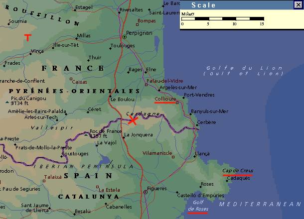
I decided to write about the geography of one of the more bizarre moments of the entire Canon, when in "Post Captain" Stephen and Jack, disguised as a bear, cross the Pyrenee Mountains from French Catalonia into Spanish Catalonia. I wondered exactly where this crossing took place and also just where Stephen's castle in Spain sat. A map in Dean King's "Harbors and High Seas" gives a general idea, but is rather vague in the details.
This a map of the French-Spanish Catalonian border. The red "X" towards the center marks the crossing spot. Towards the coast, its name underlined in red, is Collioure, the longtime residence of POB. Further south are two features mentioned in "Post Captain" as being visible from the summit when crossing the mountains, the Golf de Roses and Cap de Crues. Oh, and that red "T" in the upper left corner of the map? Well, that is Tarerach (or Trahac), the village where my forebears lived three centuries ago, although my great-to-the-fifth-grandfather emigrated to Canada several decades too soon to see the great Travelling Bear Show.
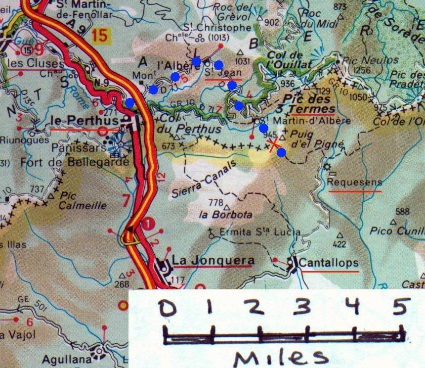
After Stephen discovers the village of Le Perthus on the French-Spanish border to be filled with French police and soldiers, he explains to Jack the alternative route. Concealed near the main road into Le Perthus, he points out their path: "The pink roof, and behind it a peak? And to the right of that, beyond the forest, a bare mountain? That is the frontier, joy, and in the dip there is a pass, a path down to Recasens and Cantallops." Their journey is described in some detail: "across to the cart-track up to Saint- Jean de l'Abere. Up and up, the moon clearing the forest ahead of them ... Up and still up. After the last barn the track dwindled to a ribbon and they had to walk in single file ... Always this eternal climb, sometimes across the leaf-filled bed of a stream, sometimes up an open slope so steep that it was hands and knees: and the sirocco ... The beech-trees gave way to pines ... Endless pines on an endless mountain, their roaring tops bowing northwards in the wind ... The pines. Then suddenly no more pines - a few stunted bushes, heather, and the open turf. They were on the upper edge of the forest, a forest ruled off sharp, as though by a line ... Stephen waited, searching the bushes, the bare rocks, from the far left to the far right, before he walked out, paced over the short grass to a stone set on the very top of the slope, a squared stone with a red-painted cross cut into it. 'Jack,' said he, leading him beyond the boundary mark, ' I bid you welcometo my land. We are in Spain ...' Jack sat heavily on the stone, gasping inwards filling his starved lungs ... In front of him the ground fell suddenly - almost a precipice - two thousand feet below there was Spanish Catalonia spread out in the morning light. A high-towered castle just below them on a jutting rock - a lobbed stone would reach it; the Pyrenees folded away and away in long fingers to the plain; square distant fields, vineyards green; a shining river winding left-handed towards the great sweep of the sea; the Bay of Rosas with Cap Creus at the far northern end - home water, and now the hot wind smelt of salt." This crossing spot is close to Stephen's castle -- that castle visible below them, although Jack has obviously exagerratedin his thought that he could lob a stone into it. Stephen estimates that it is "a thousand feet or so" below them and will take an hour to get there. Given the steepness of the terrain and Jack's fatigued condition, we can conclude that the castle could not be more than a mile or two from the border. Besides, the castle's lands extend right to the border, for Stephen says at the crossing point, "'This is my sheepwalk. What is more,' he said, looking sharply at the cowpats, 'I believe those French dogs from La Viall have been sending their cattle over to eat my grass.'"
On map below, I have marked Stephen and Jack's route with a series of blue dots. The path from the Le Perthus road to St. Jean de l'Abere is clearly visible and then south of St. Jean the road and path leading up and across the border (which is designated by a line of black crosses). The peak mentioned by Stephen when pointing out their path to Jack at the beginningis apparently the Pic de 3 Thermes, about a mile and a half northeast of the crossing point. And Stephen's castle? Well, from the description of its location in M&C, I think a good candidate is the Castell de Requesens (Recasens) of which I found a brief mention on a Spanish website about the Albera mountain range: "Notable from the mediaeval castles is Requesens, constructed in the 14th century. Situated north of the village of Cantallops, it towers over the thick forests which cover the slopes of the Neulós peak."
Bruce Trinque
41*19'41"N 72"12'40"W
6th September 1998